|
|
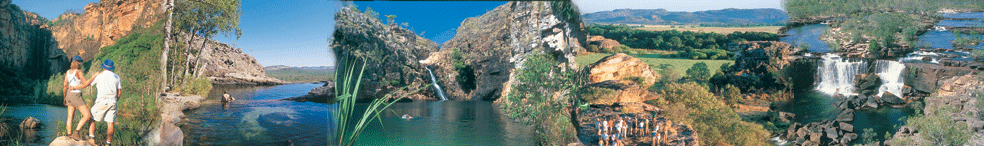
Kakadu Habitats in
Kakadu National Park, Northern Territory Australia
|
|
The name Kakadu:
|
| Comes come the Aboriginal Floodplain Language of
Gagudiju. The kakadu National Park cover around 20,000 km. This
includes the Aboriginal Traditional Lands of a number of clans.
Kakadu is managed jointly by it's Aboriginal Traditional Owners
and the Commonwealth Organization Environment Australia. |
 |
|
Ancestors:
|
|
It is respected that kakadu is a cultural landscape.
Being shaped by the spiritual ancestors of the Aboriginal
peoples during the Creation Time. The ancestors (first people)
were said to have journeyed across the country creating the
landforms, animals, plants and the Aboriginal people (Bininj/Mungguy).
They came with laws to live by: language, kinship, ceremony
and ecological catetakership. They taught these peoples how
to live and look after the lands.
|
|
| World Heritage Area: |
|
Kakadu National Park approximatley 230klm from
Darwin in Northern Territory, Australia is one of the few
World Heritage Areas that has been designated for it's natural
and historical heritage. This National Park protects one of
the world's best examples of rock art. Kakadu also protects
the entire catchment of a large tropical river, the South
Alligator, creating one of the most remarkable collections
of flora and fauna anywhere in the world.
|
|
Kakadu Habitats
|
|
Savanna Woodlands:
Woodlands makeup nearly 80% of this park. Mostly eucalypts
and tall grasses. Here the woodland support a large range
of wildlife and a greater variety of plants than else where
in the park.
Monsoon Forests: These
forests occur in small pockets. Birds and Flyying Foxes link
the plants by dispersing it's pollen.
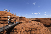
Stone Coountry: At the
east of the park's highway a large dominating escarpment of
standstone "Arnhem Land Plateau" exists. From 30m
to 300 m it covers the historical spiritual drawings of Ubirr
and Nourlangie.
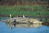
Tidal Flats and Coast:Kakadu
protects around 500 sq km of estuarine and costal areas. Most
of which are mangrove lined forests forming an excellent nursury
for fish. kakadu's wetlands include billabongs, floodplains,
rivers, estuarine and coastal areas. These areas are significantly
imortant and recognised as areas ofr mirgratory birds.
Floodplains and Billabongs:
These floodplains tend to undergo dramatic seasonal changes.
This can be viewed from the Arnhem Highway when passing the
South Alligator floodplain. After the wet season rainfalls,
a sea flows over the plains for hundreds of ksquare kilometres
in patches. When these plains start to dry out the waterbirds
and crocodiles seek refuge in remainingareas such as the renowned
Yellow Water Billabong.
Southern Hills and Ridges: In
the south of Kakadu National Park, hill sand broken ridge
lines are a result off millions of years of erosion.the unusaul
geology of this area is reflected int he diversity of habitats
and the presence of plants and animals that do not occur anywhere
else in the world.
|
Fire
|
|
Fire is a major influence in the Australian
environment. Fire has been a very important factor in Aboriginal
life over the previous generations and 1000's of years. it
was used for cooking, signalling, making hunting easier, to
attract animals,to p[rotetc foods like Yams and finally to
"clean" the country. before the long hot dry season
approaches.
|
|
Parks & Wildlife Commission of the Northern Territory
Head Office - Goyder Centre 25 Chung Wah Tce Palmerston, NT
0830
PO Box 496 Palmerston NT 0831
Ph: +61 (0) 8 8999 5511 |
|
Kakadu National Park - Seasons
But Australia's Kakadu sees seasons of varied extremes --
so varied, in fact, that the park's longtime aboriginal inhabitants
have divided the year into six distinct seasons.
• Kakadu
Seasons - Gunumeleng Pre-Monsoon Storm Season - Gunumeleng,
from mid-October to late December, may in fact last from a
few weeks to several months.
• Kakadu
Seasons - Gudjewg - Monsoon Season - Gudjewg, from January
to March, can be described as the 'true' wet season.
• Kakadu
Seasons - Banggereng - Knock 'em down storm Season - Banggerreng,
in April, is the season when the rain clouds have dispersed
and clear skies prevail.
• Kakadu
Seasons - Yegge - Cooler but still humid Season - Yegge,
from May to mid-June, is relatively cool with low humidity.
• Kakadu
Seasons - Wurrgeng - Cold Weather Season - Wurrgeng, from
mid-June to mid-August, is the 'cold weather' time; humidity
is low, daytime temperatures are around 30°C and night-time
temperatures are around 17°C.
• Kakadu
Seasons - Gurrung - Hot Dry Weather - Gurrung, from mid-August
to mid-October, is hot and dry.
Resources
• www.parksandwildlife.nt.gov.au/
• www.environment.gov.au/parks/
• www.facebook.com/RoadReportNT
• www.roadreport.nt.gov.au/
• www.ntlis.nt.gov.au/roadreport/
• www.toiletmap.gov.au/
• www.travelnt.com/
• https://www.northaustralianhelicopters.com.au/
|

|
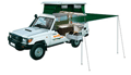
| 4WD Cars &
4WD Campers |
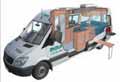
2WD Campers
& Motorhomes |
No Hidden
Costs |
• Take your adventure OFF-ROAD!
• The ultimate camping experience
• 4WD Campervans also available |
• Great holidays at affordable prices
• Spacious and feature rich!
• Perfect getaway for families & couples |
• All applicable fees and charges included
• Detailed price breakdown
• Know what you're paying for! |
|
|


 Click
here for manual old fashion customized quote Click
here for manual old fashion customized quote

Example of a 4wd camper hire
Click
here email us your enquiry if your not sure
If you don't wish a instant quote and wish a manual customised
one then:
Please include this in your request for availability and quote.
 Full
Name Full
Name
Country
of residence
Main
Driver/Hirer Licence issued from which country
Number
of those travelling
Ages
of drivers
Ages
of children under 12 (child seat guidelines)
Telphone
No. + country code
Exact
start and Finish date and such as Darwin to Broome
Route
such as Gibb River Road
|
|
Adds by Australia 4 Wheel Drive Rentals
|
|
|
|
|
|
|
|
|
|
|
|
|
|
|
|
|
 www.kakadunationalparkaustralia.com
is part of the specialist for selfdrive leisure vehicle rentals
and tour specialist including camping and accommodated one
day or extended tours and safaris from the group of Goholi
groop being an experienced respected licensed Travel Agent
in Darwin, Northern Terriotry Australia (Tel +61 (0) 8 7999
7511). Why come to us - Let us try to get you a discount off
the recommended rates with professional and experienced service.
www.kakadunationalparkaustralia.com is an 'Affiliate'
of the Australia 4 Wheel Drive Rentals group of sites. A licensed
Australian Travel Agent based in Northern Territory Australia. www.kakadunationalparkaustralia.com
is part of the specialist for selfdrive leisure vehicle rentals
and tour specialist including camping and accommodated one
day or extended tours and safaris from the group of Goholi
groop being an experienced respected licensed Travel Agent
in Darwin, Northern Terriotry Australia (Tel +61 (0) 8 7999
7511). Why come to us - Let us try to get you a discount off
the recommended rates with professional and experienced service.
www.kakadunationalparkaustralia.com is an 'Affiliate'
of the Australia 4 Wheel Drive Rentals group of sites. A licensed
Australian Travel Agent based in Northern Territory Australia.
Goholi Pty Ltd
Postal: GPO Box 380, Darwin, NT 0801
Email: info@australia4wdrentals.com
www.kakadunationalaprkaustralia.com has affliation with the
following links
• http://www.australia4tours.com
• http://www.kakadu-tours.com
• http://www.australia4wheeldriverentals.com
• http://www.australia4wdrentals.com
•Home
• Contact
Us • Site
Disclaimer • Weather
Reports • Currency
Conversion • General
Links • Site
Map
Australian Tour Information - Mission Statement
Please note some of these links are supplied only as a link
for information our company has no affliation some of these
links. Important;
This site is for the beneift of those researching for their
next vacation to Kakadu National Park in Northern Territory
Australia also know as the 'Top End'.
Australian Kakadu National Park travel guide and information
is not the offical site - the offical government site is http://www.kakadu.com.au.
This search site offering links to Kakadu, Litchfield, Uluru,
Darwin and Northern Territory accommodations, tours, safaris,
activities, nature parks, nature reserves and adventure activities.
|
|
|
|