|
|
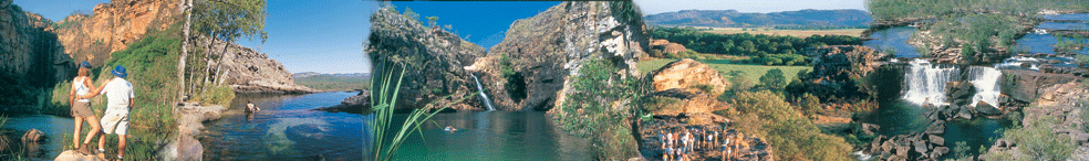
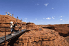
Where is Kakadu National Park
Kakadu National Park an Australian Natural
Icon covers almost 20,000 square kms and is 253 kms East of
Darwin the capital city of the Northern Territory, Australia.
Kakadu National Park is a World Heritage
listed area that has been listed for it's cultural and natural
heritage and Kakadu is the largest terrestrial national park
in Australia. Life in the park does depends on the water,
also in respect to the tropical monsoon climate that produces
the downpours of the tropical humidity of the "wet" season,
and the milder weather of the "dry" season.
Kakadu National Park is the gateway
to Arnhemland. The sealed roads from Darwin to Kakadu is via
the Arnhem Highway and from Katherine to Kakadu National Park
via the Kakadu Highway. The Bowali
Visitor Centre near Jabiru
in Kakadu National Park is located 253 km from Darwin
in Northern Territory Australia via the Arnhem
Highway entrance. If travelling by road, you should allow
3 hours travelling time from Darwin.
Kakadu is the second largest national
park in the world and and is home to approximate number of
species: Mammals: 62, Reptiles: 123+, Birds: 280, Freshwater
Fish: 51, Insects: 10,000, Frogs: 25, Plants: 1,275. (many
are rare and occur only in Kakadu)
|
 |
Kakadu National Park - Seasons
But Australia's Kakadu sees seasons of varied extremes --
so varied, in fact, that the park's longtime aboriginal inhabitants
have divided the year into six distinct seasons.
|
|
Gunumeleng Pre-Monsoon Storm Season
Gunumeleng, from mid-October to late December, may in fact last
from a few weeks to several months. It is the pre-monsoon season
of hot weather that becomes more and more humid. Thunderstorms
build in the afternoons and scattered showers bring a tinge
of green to the dry land. As the streams begin to run, acidic
water that washes from the floodplains can cause fish to die
in billabongs with low oxygen levels. Waterbirds spread out
as surface water and new growth become more widespread. Barramundi
move from the waterholes downstream to the estuaries to breed.
This was when Bininj/Mungguy moved camp from the floodplains
to the stone country, to shelter from the violent storms of
the coming wet season. |
Gudjewg - Monsoon Season
Gudjewg, from January to March, can be described as the 'true'
wet season. It is a time of thunderstorms, heavy rain and flooding.
The heat and humidity generate an explosion of plant and animal
life. Spear grass grows to over 2 metres tall and creates a
silvery-green hue throughout the woodlands. Magpie geese nest
in the sedgelands. Flooding may cause goannas, snakes and rats
to seek refuge in the trees. Eggs and stranded animals are a
good food source for Bininj/Mungguy during this time. |
Banggereng - Knock 'em down storm Season
Banggerreng, in April, is the season when the rain clouds have
dispersed and clear skies prevail. The vast expanses of floodwater
recede and streams start to run clear. Most plants are fruiting
and animals are caring for their young. Violent, windy storms
early in this season flatten the spear grass; they are called
'knock 'em down' storms. |
Yegge - Cooler but still humid Season
Yegge, from May to mid-June, is relatively cool with low humidity.
Early morning mists hang low over the plains and waterholes.
The shallow wetlands and billabongs are carpeted with water
lilies. Drying winds and flowering Darwin woolly butt tell Bininj/Mungguy
that it is time to start burning the woodlands in patches to
'clean the country' and encourage new growth for grazing animals.
|
Wurrgeng - Cold Weather Season
Wurrgeng, from mid-June to mid-August, is the 'cold weather'
time; humidity is low, daytime temperatures are around 30°C
and night-time temperatures are around 17°C. Most creeks stop
flowing and the floodplains quickly dry out. Burning continues,
extinguished by the dew at night. By day, birds of prey patrol
the fire lines as insects and small animals try to escape the
flames. Magpie geese, fat and heavy after weeks of abundant
food, and a myriad of other waterbirds crowd the shrinking billabongs.
|
Gurrung - Hot Dry Weather
Gurrung, from mid-August to mid-October, is hot and dry. It
is still 'goose time' but also time for Bininj/Mungguy to hunt
file snakes and long-necked turtles. Sea turtles lay their eggs
on the sandy beaches of Field Island and West Alligator Head
and goann as rob their nests sometimes. White-breasted wood
swallows arrive as thunderclouds build, signalling the return
of Gunumeleng. |
|
The Climate of the Kakadu Region
Kakadu is located in the tropics, 12 to 14° south of the
Equator.
The climate is monsoonal, characterised by two major seasons:
the dry season and the wet season. The 'build up' describes
the transition between these two seasons.
During the dry season (April/May to September), dry southerly
and easterly trade winds predominate. Humidity is relatively
low and rain is very unusual.
At Jabiru the average maximum temperature for June-July is
32°C. During the 'build up' (October to December) conditions
can be extremely uncomfortable with high temperatures and
high humidity.
However 'build up' storms are impressive and lightning strikes
are frequent. In fact the Top End of Australia records more
lighting strikes per year than any other place on earth.
At Jabiru the average maximum temperature for October is
37.5°C.
The wet season (January to March/April) is characterised
by warm temperatures and, as one would expect, rain.
Most of the rain is associated with monsoonal troughs formed
over Southeast Asia, although occasionally tropical cyclones
produce intense heavy rain over localised areas.
At Jabiru the average maximum temperature for January is
33°C.
Annual rainfall in Kakadu National Park ranges from 1,565
mm in Jabiru to 1,300 mm in the Mary River region.
The following charts provide an indication of rainfall, temperatures
and humidity within the Kakadu region. Data for the charts
was sourced from the Bureau of Meteorology, Darwin.
|
|
| All credits
to http://www.environment.gov.au |

|
Kakadu National Park - Seasons
But Australia's Kakadu sees seasons of varied extremes --
so varied, in fact, that the park's longtime aboriginal inhabitants
have divided the year into six distinct seasons.
• Kakadu
Seasons - Gunumeleng Pre-Monsoon Storm Season - Gunumeleng,
from mid-October to late December, may in fact last from a
few weeks to several months.
• Kakadu
Seasons - Gudjewg - Monsoon Season - Gudjewg, from January
to March, can be described as the 'true' wet season.
• Kakadu
Seasons - Banggereng - Knock 'em down storm Season - Banggerreng,
in April, is the season when the rain clouds have dispersed
and clear skies prevail.
• Kakadu
Seasons - Yegge - Cooler but still humid Season - Yegge,
from May to mid-June, is relatively cool with low humidity.
• Kakadu
Seasons - Wurrgeng - Cold Weather Season - Wurrgeng, from
mid-June to mid-August, is the 'cold weather' time; humidity
is low, daytime temperatures are around 30°C and night-time
temperatures are around 17°C.
• Kakadu
Seasons - Gurrung - Hot Dry Weather - Gurrung, from mid-August
to mid-October, is hot and dry.
Resources
• www.parksandwildlife.nt.gov.au/
• www.environment.gov.au/parks/
• www.facebook.com/RoadReportNT
• www.roadreport.nt.gov.au/
• www.ntlis.nt.gov.au/roadreport/
• www.toiletmap.gov.au/
• www.travelnt.com/
• https://www.northaustralianhelicopters.com.au/
|
|
|
| 4WD Cars &
4WD Campers |
2WD Campers
& Motorhomes |
No Hidden
Costs |
• Take your adventure OFF-ROAD!
• The ultimate camping experience
• 4WD Campervans also available |
• Great holidays at affordable prices
• Spacious and feature rich!
• Perfect getaway for families & couples |
• All applicable fees and charges included
• Detailed price breakdown
• Know what you're paying for! |
|
|


 Click
here for manual old fashion customized quote Click
here for manual old fashion customized quote

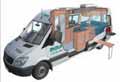
Example of a 4wd camper hire
Click
here email us your enquiry if your not sure
If you don't wish a instant quote and wish a manual customised
one then:
Please include this in your request for availability and quote.
 Full
Name Full
Name
Country
of residence
Main
Driver/Hirer Licence issued from which country
Number
of those travelling
Ages
of drivers
Ages
of children under 12 (child seat guidelines)
Telphone
No. + country code
Exact
start and Finish date and such as Darwin to Broome
Route
such as Gibb River Road
|
|
Adds by Australia 4 Wheel Drive Rentals
|
|
|
|
|
|
|
|
|
|
|
|
|
|
|
|
|
 www.kakadunationalparkaustralia.com
is part of the specialist for selfdrive leisure vehicle rentals
and tour specialist including camping and accommodated one
day or extended tours and safaris from the group of Goholi
groop being an experienced respected licensed Travel Agent
in Darwin, Northern Terriotry Australia (Tel +61 (0) 8 7999
7511). Why come to us - Let us try to get you a discount off
the recommended rates with professional and experienced service.
www.kakadunationalparkaustralia.com is an 'Affiliate'
of the Australia 4 Wheel Drive Rentals group of sites. A licensed
Australian Travel Agent based in Northern Territory Australia. www.kakadunationalparkaustralia.com
is part of the specialist for selfdrive leisure vehicle rentals
and tour specialist including camping and accommodated one
day or extended tours and safaris from the group of Goholi
groop being an experienced respected licensed Travel Agent
in Darwin, Northern Terriotry Australia (Tel +61 (0) 8 7999
7511). Why come to us - Let us try to get you a discount off
the recommended rates with professional and experienced service.
www.kakadunationalparkaustralia.com is an 'Affiliate'
of the Australia 4 Wheel Drive Rentals group of sites. A licensed
Australian Travel Agent based in Northern Territory Australia.
Goholi Pty Ltd
Postal: GPO Box 380, Darwin, NT 0801
Email: info@australia4wdrentals.com
www.kakadunationalaprkaustralia.com has affliation with the
following links
• http://www.australia4tours.com
• http://www.kakadu-tours.com
• http://www.australia4wheeldriverentals.com
• http://www.australia4wdrentals.com
•Home
• Contact
Us • Site
Disclaimer • Weather
Reports • Currency
Conversion • General
Links • Site
Map
Australian Tour Information - Mission Statement
Please note some of these links are supplied only as a link
for information our company has no affliation some of these
links. Important;
This site is for the beneift of those researching for their
next vacation to Kakadu National Park in Northern Territory
Australia also know as the 'Top End'.
Australian Kakadu National Park travel guide and information
is not the offical site - the offical government site is http://www.kakadu.com.au.
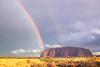
This search site offering links to Kakadu, Litchfield, Uluru,
Darwin and Northern Territory accommodations, tours, safaris,
activities, nature parks, nature reserves and adventure activities.
|
|
|
|